


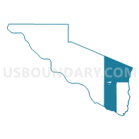
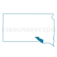
VTD precinct 1, Charles Mix County, South Dakota
About
Outline

Summary
| Unique Area Identifier | 667100 |
| Name | VTD precinct 1 |
| County | Charles Mix County |
| State | South Dakota |
| Area (square miles) | 213.63 |
| Land Area (square miles) | 212.84 |
| Water Area (square miles) | 0.79 |
| % of Land Area | 99.63 |
| % of Water Area | 0.37 |
| Latitude of the Internal Point | 43.08934550 |
| Longtitude of the Internal Point | -98.25696630 |
Maps

Graphs
Select a template below for downloading or customizing gragh for VTD precinct 1, Charles Mix County, South Dakota


Neighbors
Neighoring Voting District (by Name) Neighboring Voting District on the Map
- 006 NIO Precinct, Knox County, NE
- Bristow - Mullen - Lynch - Bush Precinct, Boyd County, NE
- VTD precinct 2, Charles Mix County, SD
- VTD precinct 4, Charles Mix County, SD
- VTD precinct 5, Charles Mix County, SD
- VTD precinct 6, Hutchinson County, SD
- VTD-Avon precinct 2, Bon Homme County, SD
- VTD-precinct 13, Charles Mix County, SD
- VTD-precinct 3, Douglas County, SD
- VTD-precinct 5, Douglas County, SD
- VTD-Wagner precinct 3 ward 1 (a), Charles Mix County, SD
- VTD-Wagner precinct 3 ward 2 (b), Charles Mix County, SD
- VTD-Wagner precinct 3 ward 3 (c), Charles Mix County, SD
Top 10 Neighboring County Subdivision (by Population) Neighboring County Subdivision on the Map
- Wagner city, Charles Mix County, SD (1,566)
- Lawrence township, Charles Mix County, SD (543)
- Highland township, Charles Mix County, SD (456)
- Northwest Bon Homme UT, Bon Homme County, SD (403)
- Bryan township, Charles Mix County, SD (358)
- Howard township, Charles Mix County, SD (273)
- Wahehe township, Charles Mix County, SD (266)
- Choteau Creek township, Charles Mix County, SD (213)
- Raymond township, Knox County, NE (207)
- Lone Tree township, Charles Mix County, SD (170)
Top 10 Neighboring Place (by Population) Neighboring Place on the Map
Top 10 Neighboring Unified School District (by Population) Neighboring Unified School District on the Map
- Wagner School District 11-4, SD (3,830)
- Andes Central School District 11-1, SD (2,242)
- Tripp-Delmont School District 33-5, SD (1,540)
- Avon School District 04-1, SD (1,158)
- Armour School District 21-1, SD (1,054)
- Lynch Public Schools, NE (593)
Top 10 Neighboring State Legislative District Lower Chamber (by Population) Neighboring State Legislative District Lower Chamber on the Map
Top 10 Neighboring State Legislative District Upper Chamber (by Population) Neighboring State Legislative District Upper Chamber on the Map
- State Senate District 40, NE (31,744)
- State Senate District 43, NE (31,106)
- State Senate District 21, SD (21,057)
- State Senate District 19, SD (19,075)
Top 10 Neighboring 111th Congressional District (by Population) Neighboring 111th Congressional District on the Map
Top 10 Neighboring Census Tract (by Population) Neighboring Census Tract on the Map
- Census Tract 9677, Bon Homme County, SD (3,616)
- Census Tract 9403, Charles Mix County, SD (3,323)
- Census Tract 9402, Charles Mix County, SD (3,142)
- Census Tract 9762, Knox County, NE (3,106)
- Census Tract 9696, Douglas County, SD (3,002)
- Census Tract 9758, Boyd County, NE (2,099)
- Census Tract 9688, Hutchinson County, SD (1,914)
Top 10 Neighboring 5-Digit ZIP Code Tabulation Area (by Population) Neighboring 5-Digit ZIP Code Tabulation Area on the Map
- 57380, SD (3,470)
- 68760, NE (1,364)
- 57313, SD (1,128)
- 57376, SD (1,010)
- 57315, SD (987)
- 57330, SD (625)
- 68746, NE (480)
- 57329, SD (258)